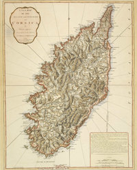
VOUS ÊTES ICI : ACCUEIL HISTOIRE 18E SIÈCLE JEFFERYS THOMAS, A NEW MAP OF THE ISLAND AND KINGDOM OF CORSICA. LONDRES, 1794
Ne manquez pas...
Parcourez-ici les rubriques
-
Territoires 975
- Les 360 communes corses361
- Les hameaux15
- Les villages abandonnés3
- La Corse de l'intérieur144
- La Corse du littoral122
- La Corse urbaine41
- Les montagnes35
- Les cours d'eau76
- Les lacs et les étangs53
- Les plages37
- Sites touristiques11
- Les randonnées3
- Les sentiers5
- La Corse en Méditerranée2
- Livres sur le patrimoine de la Corse66
- I nostri paesi in lingua nustrale cù l'ADECEC1
- Terre et mer 154
-
Histoire 679
- Préhistoire13
- Antiquité4
- Moyen-Age30
- 16e siècle12
- 17e siècle4
- 18e siècle121
- 19e siècle76
- Histoire contemporaine51
- La Première Guerre mondiale (1914-1918)17
- La Seconde Guerre mondiale (1939-1945)87
- Histoire du FLNC et du nationalisme43
- Histoire des villes et villages corses29
- Iconographies anciennes15
- Livres sur l'histoire de la Corse146
- Divers / Rencontres31
-
Histoire (patrimoine) 1294
- Sites historiques483
- Forts, châteaux et citadelles33
- Tours génoises39
- Eglises, chapelles et couvents281
- Monuments aux morts34
- Ponts23
- Places20
- Musées21
- Musée Fesch25
- Les statues publiques en Corse33
- Photos et cartes postales anciennes123
- Cartes anciennes33
- Timbres26
- Monnaies et médailles36
- Blasons, armoiries, écussons et devises27
- La Corse dans le monde3
- Divers54
-
Histoire (personnages historiques) 309
- Le Cardinal Fesch (1763 - 1839)2
- Ghjuvan'Petru Gaffory (1704-1753)1
- Sambucucciu d'Alandu (13.. - 13..)2
- Vincentello d'Istria (1380-1434)12
- Sampiero Corso (1498-1567)10
- Théodore de Neuhoff (1694-1856)5
- Pasquale Paoli (1725-1807)64
- Napoléon Bonaparte (1769-1821)73
- Héros de la Résistance26
- Les bandits célèbres10
- Les autres personnages104
- Généalogie 18
- Littérature et bibliothèques 834
- Théâtre et spectacles vivants 43
- Cinéma et documentaires 40
- Danse 8
- Musique 299
- Arts plastiques 116
- Bande dessinée 125
- Légendaire 35
- Savoir faire 131
- Médias 268
- Politique et personnalités publiques 320
- Evénements culturels et religieux 176
- Langue corse 126
-
Sport (sauf football) 155
- Affiches d'événements sportifs6
- Autres sports26
- Clubs de basket8
- Clubs de handball16
- Clubs de rugby13
- Clubs de volley8
- Figures du sport27
- L'Histoire du sport corse (hors football)3
- Livres sur le sport corse7
- Rallye3
- Sports de combat6
- Sports mécaniques17
- Sports nautiques4
- Stades et complexes sportifs11
- Football 146
- Divers 55
- > Corsicathèque Press-Book 3
- > Corsicathèque English 25
Commentaires récents
SIMON, le 11 avril
bonjour, il y a une autre faute sur la devise :il s'agit de "frugifera" et non pas "frugiera". La...
omobigusew, le 25 mars
http://doxycycline-cheapbuy.site/ - doxycycline-cheapbuy.site.ankor <a...
utahijewooym, le 25 mars
http://doxycycline-cheapbuy.site/ - doxycycline-cheapbuy.site.ankor <a...
Qui sommes-nous ?
La Corsicathèque, qu'est-ce que c'est ?
Contribuez à faire grandir la Corsicathèque
Contactez-nous
Site internet réalisé par webaxis : agence web en Corse.


Soyez le premier à commenter cet article ! COMMENTER